


Document Actions
gvSIG-Desktop 1.9 Alpha. Manual de usuario.
You can add layers from disk files by selecting the option "Add Layer" and click on the "Add" button. A file browser window appears. Choose the "gvSIG Raster Driver" option from the "Files of type" pull-down menu. Now, all supported raster file types located in the directory will be shown. You can select one or more of the files to open.
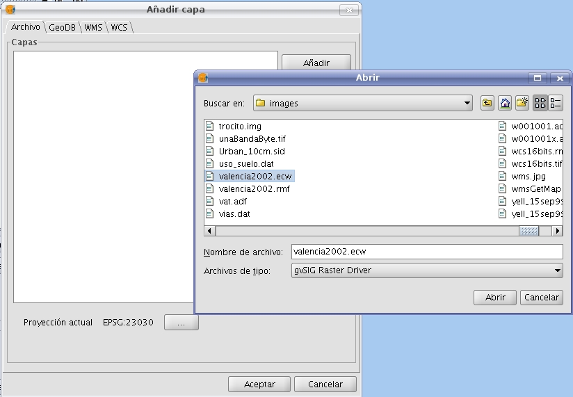
Add Layer Dialog and file browser window with the image driver
Files with the following extensions are supported:
- "Ecw"
- "sid"
- "bmp" of Microsoft
- "gif" Graphics Interchange Format
- "tif" TIFF format
- "tiff" TIFF format with 4-char extension
- "jpg" JPEG format
- "jp2" JPG200 format
- "jpeg" JPEG format with 4-char extension
- "png" Portable Network Graphics
- "vrt" GDAL Virtual Format
- "dat" of Envi
- "lan" of Erdas
- "gis" of Erdas
- "img" of Erdas
- "pix" of PCI Geomatics
- "aux" of PCI Geomatics
- "adf" of ESRI
- "mpr" of Ilwis
- "mpl" of Ilwis
- "asc" ascii grid of ArcInfo
- "pgm", PNM grayscale files
- "ppm", PNM files in RGB
- "rst" of IDRISI
- "rmf" Raster Matrix Format. This format has nothing to do with gvSIG's Raster Metafile, which cannot be loaded as raster file.
- "kap" Nautical Chart Format
- "hdr" Esri hdr
- "raw" RAW format
- "nos"
In addition, only on Linux, it is possible to open GRASS raster layers. This format requires a valid directory structure.
With certain formats, additional dialogs that prompt for parameters or options may appear before the layer is loaded, as for example:
- Introduction of headers for RAW files.
- Introduction of georeferencing if needed.
- Projection parameters.
These options will be explained in the corresponding sections.


